Government Permitting and Licensing & How to Harness the Power of Data
Governments produce and accumulate mass amounts of data that, when harnessed fully, can have a significant positive impact on citizen services, innovation, and government efficiency. Once siloed, inaccessible, and unsearchable data (still experienced by governments yet to digitize, and usually stored in paper filing rooms) is now increasingly available online, with many governments across the world, including the United States and Canada, committed to free, open data, and data-driven governance. This wealth of information is incredibly powerful when used effectively, and can be used to help forecast needs, inform better decisions, better allocate resources, and improve service delivery.
For government permitting and licensing departments, utilizing data accurately and effectively offers far-reaching benefits for staff, the public, and the economy. As noted by the Center for Government Excellence, “With a complete picture [of data], [governments] can … better align mission goals, increase consistency and confidence in decision making, and build performance intelligence.” By leveraging data management tools and systems, agencies can consolidate data in one place, and analyze available information and metrics in a digestible, succinct way.
So, with all of the data at your disposal, what is the value of investing in data management? What tools can you use to achieve data-driven governance?
The Value of a Data-Driven Approach to Government Permitting & Licensing
Prioritizing data management and analytics can help your organization provide more efficient, effective, and trustworthy public services. Data-driven permitting and licensing helps ensure information and knowledge sharing across departments; accountability and transparency into operations and performance; and proactive resource and budget management. Using real-time, accurate data - most often accessed through an online staff or public portal - you get a 360° view into your operations, important metrics, and information that can help you become more efficient and cost-effective in the present, and better predict and prepare for future demands.
For permitting and licensing departments, open data makes it easier to find and share information in real-time, even if it exists in another department -- making it quicker and easier to complete work. Key metrics and activities become easy to track and analyze using digital tools like dynamic reports and dashboards, so important data is readily available for use. For digital-first permitting and licensing departments, this could include the total number of permits, licenses, inspections, or plan checks completed, pending, or in review; new and open inquiries, their current staff owners, and expected timelines for each task; inspectors’ daily assignments; revenue and budget; and overall performance metrics and KPI’s. All of this information is available to staff, executives, and other departments, and easily shareable for public knowledge, too.
In the City of Syracuse, New York, for example, by using predictive analytics to target preventative maintenance, the City saved $800,000 in 2018 on emergency water main repairs. And in San Francisco, staff save the City $1.7 million a year by applying technology and data skills training to find efficiencies on the job.
On a larger scale, a Mckinsey Report suggests that open data can help unleash over $3 trillion in economic value globally; whereas, in Canada, a study from Natural Resources Canada, found that opening geospatial data would increase the Country’s GDP by an estimated $695 million Canadian dollars.
For the public, a data-first approach offers considerable value (Figure 3.5), and provides easy access to important information about community projects and improvements, and transparency into government operations. In Orange County, California, for example, an online e-services portal used for government permitting and other development services, allows citizens to freely view community data, including: information about land and buildings, development projects, infrastructure projects and improvements, and other important data that they may want to access -- like when a pothole on their street is scheduled to be filled, or if their neighbour got County approval for the new shed being built in his backyard. Strategic decisions based on data also help speed-up and improve permitting and licensing services. Working with real-time information available on-demand, your department can proactively respond to citizen needs before they even make a request, and anticipate needs. This could look like automatic license or permit renewal notifications, or alerts about overdue or upcoming inspections.
OECD, The Path to Becoming a Data-Driven Public Sector, Chapter 3, 2019
Evidently, utilizing data to drive policies and decisions provides many benefits. And with the right digital solution and tools - like dynamic reports, dashboards, and GIS - your permitting or licensing department can accurately capture data for success.
The Tools to Help You Accurately Capture Data: Dynamic Reports, Dashboards, and GIS
A digital permitting and licensing solution offers the ability to capture data effectively, and use it efficiently. Data-management tools like dynamic reports, dashboards, and GIS spatial data make information easier to digest in a visual format that’s easy to understand and analyze.
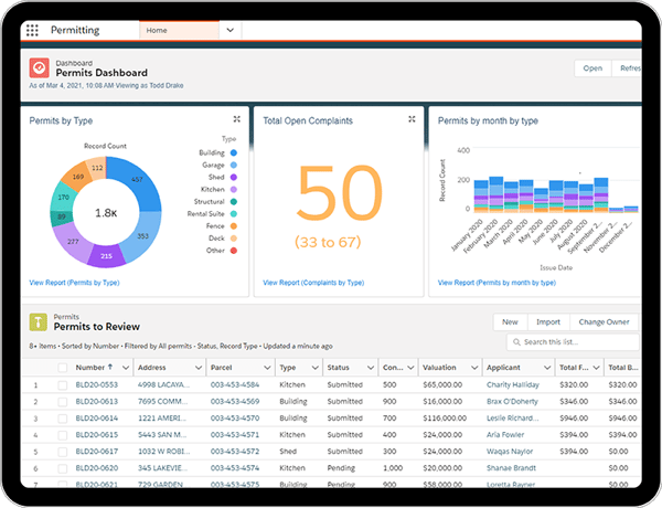
Dynamic dashboards and native reporting allow you to:
- Easily capture, track, analyze, and visualize key performance indicators and department metrics
- View the information and metrics most important or useful to your department, such as the total number of permits, inspections, plan checks, or licenses processed and approved
- Track revenue
- Monitor daily staff activities in real-time
- Grasp actionable data on-demand to make informed decisions -- eliminate the need to wait for daily, weekly, or monthly reports
- See patterns, predict problems, and identify successes
- Share department information with the public in a simple, easily accessible way
- Schedule and run reports to automatically distribute when needed
- More easily fulfill compliance requirements and adapt to change
A Permitting Dashboard

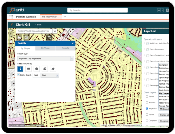
With GIS Spatial Data, you can:
- Easily view land data to make more exact and sustainable decisions about land use
- Assign fieldwork based on location, staff availability, and the optimal route
- Provide the public with a simple way to visualize community projects and history on a map
GIS Map Viewer

Ultimately, these tools help you effectively capture your permitting and licensing data to ensure efficiency, service excellence, and data transparency.
